

On this page
Give the three water-control features priority over a long sightseeing checklist
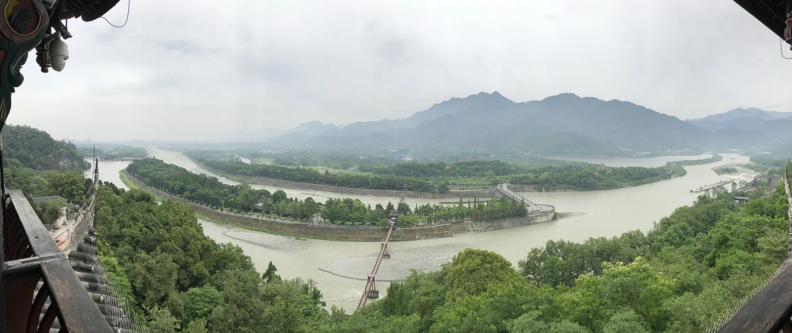
Visit Dujiangyan if you want to understand how a river can supply water while shedding excess flow and sediment. Build your first route around **Yuzui, Feishayan and Baopingkou**, then decide whether a bridge crossing, temple or hill view adds enough value for your available time and stamina. A longer route is not automatically a more informative one.
Allow roughly three hours for a considered visit to the main scenic area, with travel, ticket checks and any substantial hill extension additional. This is an editorial allowance. A compact visit can concentrate on the water-control features; a broader one can add historical interpretation and a higher view where open. Neither promises a fixed walking time or continuous step-free access.
UNESCO describes a working irrigation system originating in the third century BC and subsequently modified and enlarged. The visitor area shows the headworks of a much larger water-distribution landscape. Understanding that relationship is more useful than treating the whole system as a single old dam beside a park.
Dujiangyan and Mount Qingcheng share a World Heritage inscription, but they are separate visits with different entrances and physical demands. Confirm which attraction each ticket buys. Combining both in one day means additional transport and less time at each; choose that deliberately rather than assuming the common heritage name describes one admission area.
Three stops answer three different questions about the water
Before walking, find the three names on the current visitor map and establish the permitted route and return point. The order you encounter them may depend on your entrance. You can still read them as stages of a system by tracing water upstream and downstream on the map.
| Feature | Role to identify | Question to ask at the viewpoint |
|---|---|---|
| Yuzui · 鱼嘴 · Fish Mouth | Divides the river into inner and outer channels | Which branch supplies the irrigation side, and which follows the main river course? |
| Feishayan · 飞沙堰 · Flying Sand Weir | Provides an overflow and sediment-discharge route | Where can excess water leave the inner channel before the intake? |
| Baopingkou · 宝瓶口 · Bottle-Neck Passage | Constrains the water entering the downstream distribution system | How does the narrow rock-cut passage change the route compared with the broad river? |
Swipe to see the full comparison
UNESCO identifies these three principal components and their coordinated functions. The table's questions are a way to observe them, not a claim that your visit will reproduce a diagram's water level or that all viewpoints are open.
At Yuzui, look at the division before the decorative surroundings
Locate the dividing structure, then identify both sides from a permitted viewing position. Look at channel shape, direction and the relation between the river bend and the split. Use a site diagram if the perspective makes the branches hard to distinguish.
A published interview with Li Zhao of the Sichuan Li Bing Research Association explains how different inner and outer channel geometry responds to changing flow conditions. The useful point is that distribution changes with conditions. Do not take a popular fixed percentage as a measurement of the water in front of you.
For a child or a visitor new to engineering, ask them to point to the two possible routes before reading the explanation together. That turns the landscape into a comprehensible decision: some water must reach the plain, while the system also needs a route for too much water. Avoid counting a fast glance at the dividing tip as understanding the whole site.
At Feishayan, the apparently open space has a job
Think about what would happen if the inner channel received more water than the intake should accept. Find the relationship between the overflow, outer river and approach toward Baopingkou rather than expecting a visually dramatic freestanding building.
The International Centre for Water Hazard and Risk Management's technical account, based on a historical site visit, discusses overflow and the use of river bends in sediment handling. Its dated engineering description is background, not a current operating notice. It helps explain why the water's path and the placement of an opening matter as much as a monumental structure.
Look for the interpretation that distinguishes excess-water release from sediment management. You do not need to see sediment visibly leaving during your visit to understand the purpose. Seasonal conditions can make a textbook process less obvious; a diagram or guide should supply context rather than encourage you to walk closer to restricted water edges.
At Baopingkou, connect the rock-cut opening to the wider plain
Find the constrained passage and compare its width and direction with the river you have just followed. Ask where the water goes after passing through it. The point is not merely that people cut rock, but that the opening works with the upstream division and overflow.
The Li Zhao interview connects the cut passage with the separation of the rock mass known as Lidui. It also stresses that the waterworks have been maintained and improved across generations. The design's longevity does not mean every stone, embankment or mechanism you can see is unchanged ancient fabric.
After these stops, try describing the system in your own words: division, release of excess water and sediment, then controlled delivery. If one relationship remains unclear, revisit the diagram or ask an interpreter. This is a more rewarding conclusion than collecting three photographs whose locations you cannot explain.
Choose a route with a clear stopping point, then consider the temple or hill
For a focused visit, ask staff for the currently permitted connection among the three water-control features and a return to your intended exit. If arriving at the Lidui Park side, establish which features you can see from the initial section before deciding on a wider circuit. If beginning from a higher or opposite-bank entrance, resolve the descent and crossing before assuming you will return by the same path.
Ask three practical questions at the map: which section has steps, whether the bridge you intend to use is open, and where you can shorten the visit. A route described online as “mostly downhill” is not necessarily suitable for a wheelchair, someone who avoids suspension bridges or a person with painful knees.
Anlan Bridge, Erwang Temple and a hill viewpoint can add a wider perspective, but each is an extra walking choice. A suspension-bridge photograph does not establish that the crossing is comfortable for everyone. Keep an alternative return agreed before crossing; do not wait until fatigue or a queue makes the decision urgent.
Erwang Temple adds a different subject: how water management is remembered and honoured. A Tsinghua account of its post-earthquake conservation describes the hillside complex, its memorial association with Li Bing and Erlang, severe 2008 damage and careful sorting and reuse of salvaged components. Consider the present building as a conserved religious and commemorative place, not untouched evidence from the waterworks' founding period.
If visiting, observe how the halls and circulation adapt to the slope, then look for interpretation connecting the place with maintenance and public memory. Respect worship and conservation controls. A higher view may help place the river branches spatially, but it is optional if the climb would consume the energy needed for the rest of your trip.
Foreign passports and concessions: read the specific overseas clause
The portal's foreign-visitor clause specifies passport or residence-document entry through a staffed channel, with window purchase also available. Eligible full-time undergraduate-level or lower foreign students pay half price; other foreign visitors pay full price. Its published rates are **CNY 80 ordinary / CNY 40 student**. Resolve supporting documents first; do not apply the domestic senior-free table to an overseas passport holder.
The portal links an English-facing **Trip.com Dujiangyan Scenic Area** product and names official WeChat channels **青城山都江堰** and **悦游都江堰**. Start through that attraction-specific link or official channel and confirm that the chosen product accepts your document. A January 2026 report hosted by the Ministry of Culture and Tourism describes the scenic area's international booking and payment services, including an inbound Ticket Booking link through official WeChat. Those services are documented; this guide has not completed a purchase or tested every card.
Take the original document and confirmed order. At the staffed channel, keep both available until verification is complete. If an identity-card field will not accept your passport, change to the correct supported product or seek assistance; do not put somebody else's number into the booking.
If the site or seller shows “pending,” resolve it before travelling. A transfer invoice, a booking request and confirmed admission are different records. If a payment fails, check whether an order already exists and retain the error before submitting another purchase.
Admission does not include the vehicle, escalator or every night view
Ordinary admission excludes the vehicle, **Buyun Corridor escalator** and guiding. Ask each add-on's price, direction and deadline; an escalator does not make the entire route accessible.
If you only need a waterworks-focused walk, do not add a hill product out of habit. If you choose it for an overview, establish what walking remains at either end and where it leaves you. Buying an uphill ride is not an answer to the return route unless the return terms are also clear.
The portal lists **January–February 08:00–17:00**, **March–December 08:00–18:00**; sales stop at **17:00 / 17:30**, respectively. Plan an earlier arrival for a three-hour visit and confirm admission and clearance for your actual product.
Any night product needs its date, areas, rights and exit checked. The portal places **“Blue Tears” outside the scenic area**. Establish a photograph's actual location before buying waterworks admission for it.
The paid scenic visit and an evening town walk can complement each other, but do not confuse their hours or use an outside night scene as proof that the waterworks' daytime viewing paths remain open. Choose dinner and transport around the exit from your actual attraction, not around a city's broad marketing label.
Match the rail destination and pickup to the entrance you intend to use
If comparing rail journeys from Chengdu, search **Lidui Park · 离堆公园** as a specific destination, alongside other station choices such as Dujiangyan. Amap's first-party place record identifies an exit at Lidui Park station; use current navigation to connect the station with your intended public entrance. A station and a scenic gate sharing “park” in the name are still separate points.
Check the actual departure station, date and return train in the rail booking service. Add the Chengdu-side approach and the walk or road connection at the destination. A quoted short train duration does not describe the whole door-to-gate journey, nor establish a seat on the train you want.
For a booked road transfer, give the driver the exact entrance and agreed exit, especially if you plan a one-direction route. State whether the quote includes waiting and return. If adding Qingcheng, its transfer and admission remain extra pieces of the itinerary; a common heritage inscription cannot eliminate them.
For reduced mobility, contact visitor services about thresholds, slopes, usable crossings, toilets and vehicle boarding on a **named route**. Choose the core waterworks and an early stopping point if a full circuit is unsuitable. A local transfer arranged from the right exit is more useful than a promise to meet at a distant high viewpoint which you may never reach.
If plans change, the unused-ticket deadline depends on the channel
The portal's unused-ticket rules distinguish **悦游都江堰 My Orders: next day 23:59**, and **offline requests through 028-96526: within 30 days after the visit date**. They do not establish a refund after entry.
Use the applicable process for your own order. A different sales channel or an add-on may have different terms, so do not transfer the portal's WeChat instruction to a whole guided bundle. Save the order, request time and response if the policy is disputed. If a closure or capacity control prevents entry, ask the original channel how it records the unused ticket and handles the request.
Change the physical plan as readily as the booking plan. If high water, rain or staff restrictions remove a crossing or viewpoint, use the open interpretation and remaining waterworks stops. Restricted banks and maintenance paths are not visitor shortcuts. Understanding the coordinated engineering does not require ignoring the conditions which allow it to remain a working landscape.
Sources and editorial note
Independent actual rendered tourism-portal ticket and overseas clause read, ministry January 2026 international service report, UNESCO engineering account, named Li Bing Research Association expert interview, ICHARM historical engineering visit and Tsinghua conservation account. Original flow-reading exercises and manageable-route criteria, not a reused body. First-party map verifies named station exit; no invented rail timetable. AI-assisted desk research; no personal visit, ticket transaction or card test.
Named bridges, hill interiors and continuous accessible circuits not guaranteed open. Foreign student supporting document must be confirmed. No current exact sediment percentage, foreign-card universal success, instant rail travel or night entitlement assumed. Historical engineering and conservation sources are not daily operations notices.
- https://whc.unesco.org/en/list/1001/
- https://www.neac.gov.cn/seac/c103391/202308/1166522.shtml
- https://www.pwri.go.jp/icharm/news/news_j/ao_yoshi_trip.html
- https://www.tsinghua.org.cn/upload/file/1538195754476.pdf
- https://www.djy517.com/online.html?channelCode=mpyd
- https://www.mct.gov.cn/whzx/qgwhxxlb/sc/202601/t20260112_964074.htm
- https://ditu.amap.com/place/B0HG7LM6MU